Health of the Gualala
Until the turn of this century few scientific studies and very little scientific data were available for the Gualala River Watershed.
Over this past decade a number of studies and assessment were completed on the watershed through partnerships with State and Federal agencies, llandowners and other interested parties.
 We have acquired a solid grasp on the condition of the watershed and the sources of major impacts.
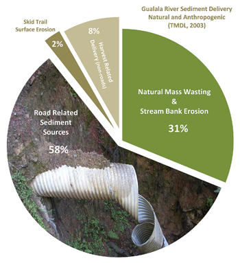
All of these studies agree, anthropogenic sediment sources are one of the main contributing factors to the decline of the health of the watershed.
Another main contributing factor is the elimination of over-story canopy from fish bearing streams during the 1950s and 1960s. This reduced shade and increased water temperatures and decreased large wood for recruitment to the stream channel.
Other contributing factors include intensive landuse; especially legacy issues from the 1950s and 1960s, very little old growth, hardwoods dominating conifers, Sudden Oak Death, direct water diversions, rural residential development and the elimination of low intensity fires that are important for healthy ecosystems.
Current Condition
Watershed data collected over the past decade are signifying a slow watershed recovery from legacy impacts. Excess sediment depositions are clearing from headwater streams but still evident in most tributaries and mainstems; over simplifying channel form and impacting salmonid habitat.
From past studies we know that the flushing of excess sediment loads in the depositional channels will take many decades; excluding continued sediment inputs from chronic and episodic events.
The GRWC in partnership with California Department of Fish and Game, the North Coast Regional Water Quality Control Board, landowners, and rural subdivisions are working hard to control anthropogenic sediment sources.
The table below shows road systems by miles that have been hydrologically disconnected over the past decade.
| Super Planning Watersheds | Acres | Road Miles | Roads per Sq. Mile | Upgraded Road Miles | Effective Roads per Sq. Mile | Percent Upgraded |
|---|---|---|---|---|---|---|
| North Fork |
30,654 | 304 | 6.42 | 84 | 4.64 | 27.70% |
| Rockpile Creek |
22,403 | 174 | 4.77 | 9 | 5.03 | 5.19% |
| Buckeye Creek |
25,784 | 249 | 6.26 | 18 | 5.80 | 7.21% |
| Wheatfield Fork |
71,492 | 476 | 4.31 | 54 | 3.82 | 11.44% |
| South Fork |
40,783 | 327 | 5.19 | 89 | 3.78 | 27.14% |
| Gualala River Watershed Total | 191,116 | 1529 | 5.19 | 254 | 4.32 | 16.62% |
On average stream canopy closure is recovering from the 1950s and 1960s logging era where overstory shade canopy was reduced from 95% in the 1940s to below 50% in the 1960s.
It is estimated that canopy closure has increased to 75% in the basin (NCWAP, 2003). However, streamside canopy now consists primarily of 50 year old small to mid-sized conifers and mixed conifer/hardwood, not ideal riparian stands for the natural recruitment of large wood into the stream channels.
The loss of mature riparian corridors and stream clearing projects in 1970s and 1980s has caused a paucity of existing instream large wood and complex root structures.
Watersheds are dynamic, constantly adjusting to change. Watershed management and restoration needs to be adaptable and the decisions made need to be based on scientific data. Without monitoring for trends and project effectiveness it is impossible to make well informed aquatic habitat management decisions and take restoration actions that enhance the watershed to pre-disturbance levels.
| Super Planning Watersheds | Acres | Stream Miles | Temperature Sites | Monitoring Reaches Proposed | Monitoring Reaches Installed |
|---|---|---|---|---|---|
| North Fork |
30,654 | 126.7 | 37 | 19 | 10 |
| Rockpile Creek |
22,403 | 88.2 | 11 | 8 | 3 |
| Buckeye Creek |
25,784 | 90.4 | 17 | 13 | 10 |
| Wheatfield Fork |
71,492 | 300.6 | 24 | 34 | 5 |
| South Fork |
40,783 | 134.2 | 21 | 14 | 5 |
| Gualala River Watershed Total | 191,116 | 740 | 110 | 76 | 33* |
*Two (2) Gualala Coastal (drain directly to the Pacific Ocean) reaches are installed on Salal and School House Creeks for a total of 35 installed reaches.
Focus Issues
Reduce anthropogenic sediment sources.
Increase in-stream habitat diversity and provide summer and winter refugia for salmonids.
Protect riparian buffer zones and/or implement large tree management in protection zones to increase center of channel canopy and potential large wood recruitment.
Promote Conservation Planning and One Forest Concepts within the watershed.
Gualala River Watershed
2009 Aerial Mosaic
(1MB)