Gualala River Watershed
Watershed Overview
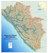
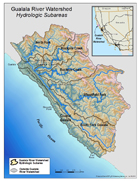
 The watershed is elongated, running over 32 miles long north-south, with an average width of 14 miles east-west. A continuous history of movement along the San Andreas and Tombs Creek faults has been a dominant force in shaping the basin.
The long linear reaches with little sinuosity in the South Fork illustrate the influence the San Andreas rift zone has in controlling the stream channels in the lower basin of the watershed.
In the eastern portions of the watershed deflected stream channels caused by the Tombs Creek Fault zone influence the headwaters of the North Fork, Rockpile Creek, Buckeye Creek and the Wheatfield Fork.
The five principal Gualala sub-watersheds in order of size start with the Wheatfield Fork at 71,492 acres which comprise 37% of the watershed, the South Fork and Gualala Mainstem at 40,783 acres is 21%, the North Fork at 30,654 acres is 16%, Buckeye Creek at 25,784 acres is 14%, and Rockpile Creek at 22,403 acres is 12%.
Historical Land Use
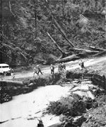
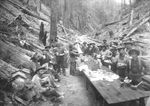 The Gualala River Watershed has produced timber since before the turn of the last century and the basin has one of longest records of timber harvesting compared to other North Coast Watersheds. The watershed has been subject to three eras of active land use:
- Old growth redwood harvesting throughout the lower alluvial basin areas from 1868 to 1911
- Tractor harvesting of remaining old growth conifer stands in the central reaches of the watershed from 1952 to 1968
- Cable/tractor harvesting of second growth coniferous stands from 1990 to present
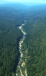
Extensive logging and road building practices have contributed to erosion and mass wasting, producing a legacy of increased sediment loads severely impacting aquatic habitat in the Gualala River and its tributaries.
Watershed Impairments
 In 1993, the USEPA listed the Gualala River on its federal Clean Water Act §303(d) list of impaired water bodies due to declines in anadromous salmonids from excessive sedimentation.
The §303(d) listing was updated in 2003, and water temperatures in the basin are now considered impaired as well.
A Technical Support Document (TSD) for the Total Maximum Daily Load for the Gualala was completed by the North Coast Regional Water Quality Control Board (NCRWQCB) in 2003.
The Gualala River TSD estimates that 85% of the anthropogenic sediment sources impacting the river today are derived from poorly constructed timber and ranch roads.
Gualala River
Watershed
Hydrologic
Subareas
Map
(8.5x11
inches PDF)
Related Info
![]()
California
Department of
Fish and Game
NCWAP Summary
CDFG, 2004
(4 MB)
![]()
Watershed Geology
NCWAP Appendix 2003
(18 MB)
![]()
Watershed Hydrology
NCWAP Appendix 2003
(1 MB)
![]()
Watershed Land use
NCWAP Appendix 2003
(18 MB)
![]()
North Coast Regional Water Quality Control Board Basin Plan
(NCRWQCB, 2011)![]()
Watershed Features Map
(1MB)